Mt. Dana

Beth.jpgTuolumne has opened! And another hiking season in the high country begins. Mt. Dana provides a great welcome to the higher elevations and I usually make it my inaugural hike in Tuolumne. It’s short (less than six miles round trip), strenuous (an elevation gain of over 3,000 feet) and propels you into the beautiful alpine landscape and atop the park’s second highest summit fairly quickly (depending on your hiking speed!).

Due to a craving for pancakes, we begin late in the morning but the sky holds no troubling clouds. "It’s all uphill from here," I keep joking as we walk. Shad kneels down to get a photo of a field of corn lilies waving their green leaves at us. He’s become more confident in his photography since his rolls of film have come back from the developer without the fix-it stickers attached.

We pass a small rock decorated with an orange paint spot and I relate to Shad the story behind this strange spot. The late ranger, Carl Sharsmith, established this trail in the 1930’s and led wildflower walks up to the Dana Plateau. At one point, he was ordered by his supervisor to paint blazes marking the trail up to Dana. He disagreed with the directive but was forced to comply. So he painted the orange spots only on small rocks, and when his supervisor left, he marched up the trail and turned all of the rocks with the orange blazes over.

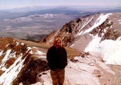
After boulder jumping up to the summit, we find only one other party at the top. Proving the small world theory true, a member of the group happens to be William Alsup, a board member of the association. We enjoy the panoramic view together and between the five of us we are able to identify most of the landmarks: Mono Lake, the White Mountains, Saddlebag Lake, Mt. Conness, Cathedral Peak, Echo Peaks, Mt. Ritter and Banner (just barely) Lembert Dome, Mt Hoffmann and Mt. Lyell.

Since it’s early in the season, the scurry down the mountain is accelerated by the large snowfields. We slide down with our raingear, laughing as we go, bumping and falling over suncups. And our pace is also quickened by the motivating factor of a Tioga Pass Resort homemade piece of pie.

Endnote: Shad consumed a rather large slice of chocolate cake; I opted for the apple pie.
Half Dome

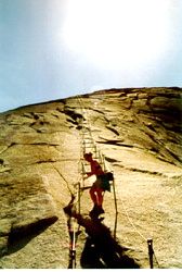
Cables.jpgDespite the crowds on this trail, it’s still a wonderful hike. Half Dome is the Yosemite icon and there is something special about standing atop this icon. I still remember my first view of that monumental rock as I drove into the valley ten years ago on route 120. A native New Englander,
I’m not used to hugeness. My mouth literally dropped open at the site of the sheer face of granite looming over 4,000 feet out of the valley.

This was my third time climbing Half Dome, and I decided to take a day off midweek in order to minimize the "highway effect." After passing the highway of people at Vernal Falls footbridge, I steer us to the lesser-used Muir Trail and my strategy works – Shad and I walk alone until we hit the top of Nevada Falls. Nevada throws her plumes of water at us in full force. I inform Shad of the cool treat that awaits us on the way down via the Mist Trail.

After a water stop in Little Yosemite Valley (the last reliable water) we head up to the summit. We both groan at the assault on our knees at the granite staircase, but as we approach the cables, we’re both revived by being so close to our goal. With the help of a second wind (and a few powerbars) we hoist ourselves up the cables and arrive at the wide expanse of the top of Half Dome.

At the top, Shad snaps many photos and even peers over the sheer drop, something I’m too scaredy-cat to do. I look around and as usual am amazed at the number of people, all in different levels of preparedness, who have made it to the top. Some have only sandals on their feet, others wear jeans and tennis shoes, others carry dehydrating cans of soda. All hiking "don’ts" but I guess they can be forgiven and I admire their persistence– being on top of an icon is a great motivator.

Glacier Point

I recommend hiking the Four Mile Trail before the Glacier Point road opens for the season, but this year there wasn’t much of a window of opportunity. The trail opened on May 8th; the road on May 15th. It’s wonderful experience being at Glacier Point alone: I’ve trudged through a foot of snow on the at the top with only myself for company. Still May isn’t too crowded, and we had a nice breeze to cool us. One more tip: Beware of the misnomer – the trail is actually 9.2 miles round-trip.

I arm myself with water and a peanut butter and jelly for the hike; Shad’s film to food ratio is quite out of balance. The photo bug has hit and he’s been sending off weekly shipments to Seattle Photoworks for developing.

They put stickers on photos in need of help, with suggestions like "Oops, check your light meter." Shad’s goal is to have a packet come back sticker free.

Switchback after switchback we trudge upward, passing a changing assortment of trees as we gain in elevation: canyon live oaks, manzanita, white furs and sugar pines. I point out to Shad a future photo opportunity as we pass stands of aspen that will blossom into brilliant yellow in the fall. When we hit the first patches of snow, small towers of bright red snowplants peek out from the ground.

The long ascent provides its rewards as we reach the top. Snow still blankets the Clark Range, and Half Dome stands guard over the Valley. Shad doesn’t even flinch when I tell him we’ll be scaling that massive granite dome on our next hike. He’s probably thinking about the photographic opportunities.

Yosemite Falls

First hike of the season! My cross-country skis have been stored away and the hiking boots waterproofed and readied for another year. My strategy has always been to complete the Yosemite Valley hikes in early spring, before the summer crowds. Just last week a snowstorm hit Yosemite (and my home), but today the sun shines and hints at the start of spring. I’ve hiked this trail countless times, and each time it rewards me with a different story of the landscape: the lighting on the granite, the varying path of the water as it crashes down the cliffs, and once, even a black bear ambling down the trail to greet me.

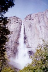
YosFalls.jpgI also have the pleasure of being able share the park with a new partner, which allows me to experience the hike through his perspective. His fresh eyes see things I’ve previously missed. He’s in good shape, but new to high-elevation hikes. I warned him of the 3,000 feet of elevation gain on this trail, but he’s proven himself to be a trooper and he’s not even breathing heavy. We both seem to hike at the same pace and have an affinity for chocolate – perhaps I’ve found the perfect hiking partner!

At the first viewpoint of the falls, a short distance past Columbia Point, we pause for photographs and enjoy the mist from the pounding water as the wind carries it to us. Shad pauses to experiment with f-stops and exposure settings; he just bought a camera and is learning photography. It’s all too technical for me—I prefer the ease of a good point and shoot. At the top of the ridge the landscape blooms with snow patches, and I assembly a snowball that my companion easily dodges. "Don’t interfere with art," he says, using his camera as a shield against a further attack.

After descending the rock staircase, we come to the to the top of the falls. Shad leans precariously over the railing in pursuit of a good photograph, while I stay further back, being a bit chicken of sheer heights. I’m close enough to see the surge of water over the cliff, a rolling motion of whiteness.

On the way down, I add a different picture to my memories of the landscape: the wind has strengthened and it plays with the falls, twisting and turning the stream of water the way the breeze will tease a curtain in an open window.